Evidence And Speculation1
This article was originally published in the FRAM Journal, 4th Series, No. 9, April 2004 with the title “The River Ore and Local Transport”.
By Andrew A. Lovejoy
The River Ore at Framlingham forms an important component in the landscape of the town, not least with its over-large population of mallards, who provide endless enjoyment to pedestrians walking along Riverside, and irritation to drivers obliged to share the road with ever-hungry ducks.
The river itself rises just north of World’s End Farm above Saxtead Little Green.
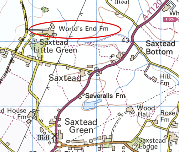
It then flows through Saxtead Bottoms, Framlingham Mere, the town itself, and Parham and Hacheston, then below Marlesford joins the River Alde, which in turn flows to the sea at Orford Ness, having passed through Aldeburgh and Orford. Interestingly the name “River Ore” re-asserts itself as the commonly-used term for the conjoined rivers on the approach to the sea.
There is no documentary evidence known to this author, which suggests that the Ore was commercially navigable in the past. A survey of the Framlingham Mere of 1789 refers to the River Ore, but not in any navigable context2. For cartographic purposes, the Ore was noted in print on the first (one-inch) Ordnance Survey map of the Framlingham area, published in the 1830s. Clearly therefore, any case for the navigability of the Ore must be built around more indirect evidence. `
There are one or two pieces of circumstantial evidence that might support the hypothesis that the river was used for transportation in the medieval period. At that time the Mere certainly was a place where boats were kept3. And in the eighteenth century an anchor was discovered in the Mere4. Furthermore, it may be significant that ships are carved on the pillars of Parham church, past which of course the River Ore flows5.
A case can also be made out of logistic necessity, for the presumption that the Ore was used for transporting stone and other building materials, as they were used in the construction of Framlingham Castle and St. Michael’s Church. Five different building materials were used in the construction of the Castle and the church, three of which were certainly not local. They comprise Caen rock from Normandy, Ketton stone from Rutlandshire, Barrock rag from Northamptonshire, and also septaria and flints6. Such a mass of heavy material must surely, in part at least, have been conveyed to its destination by water. The transport of heavy goods by land was, until the end of the eighteenth century, prohibitively expensive. Stone is said to have doubled in price for every few miles it was carried by wagons across country. Freight rates for river-borne traffic were much less than half the rates for land carriage7. In shore, the few English quarries able to send their stone far afield at that time depended in almost every case on the accessibility of water transport8.
It is quite clear from a map showing the relationship of medieval castles in Suffolk to the river systems of the county that nearly all of their sites are on rivers. Framlingham Castle is no exception9. Suitable transport of materials was essential for successful building projects in the middle ages. The River Ore might just have been the right answer for Framlingham.
Examples can be found elsewhere of the adoption of water transport for major building developments. A canal which was constructed from the site of Butley Priory to Butley River was certainly used for the transport of materials for the building of the Priory10.
On a national scale, the castles built in Edward l’s reign (1272-1307) along the Welsh border, almost all had a means of access to the sea11. The case for assuming that, all things being equal, the River Ore must have been used for conveying stone and other materials to Framlingham begins to carry conviction.
The River Ore today in its upper reaches is really little more than a ditch, which shows its full potential only in flood conditions. How could it have had commercial transport status? At the time the Castle was constructed at the end of the twelfth century, the sea level stood higher than today12. The Ore, despite its relative proximity to its mother stream, the River Alde at Marlesford, was not tidal. Nevertheless, the Aide at high tide could have acted as a dam which, when coupled with the head of water created by the Mere (22 acres in 1200)13, might have kept the level of the River Ore at a functional level for transportation. One wonders, were the rivers of East Suffolk in medieval times more substantial than is now the case? It is impossible, categorically, to answer this, but it is pertinent to note that the Mere, a pre-historic feature perhaps over 10,000 years old14, was much larger in the past. The Mere today measures barely 20% of its size around 1200 AD15. Clearly, with damming at its southern exit, the Mere could have provided a substantial head of water. That head was used to provide energy for a tannery which lay on the site of the present Elms development off Bridge Street, with also a mill sited below where the river left the Mere16. The River Ore in past centuries seems to have been a more considerable stream than it is now.
One other form of navigation should be mentioned. Even in medieval times, the Ore could have been of only marginal utility if its normal depth was insufficient for water transport. The use of the flash flood system of navigation may have provided the answer, as was the case with other rivers17. The Ore might have been temporarily dammed downstream of a boat and a head of water built up to enable it to travel upstream to the Mere. The boat could then continue on its journey until it again became grounded. The process of damming could then be repeated.
It seems that the River Ore may have been at one time in a condition to be used for transporting heavy materials. The circumstantial evidence, plus a scenario common to several sites in Suffolk, may suggest one is on credible ground in claiming a navigable use for the River Ore. However, the study of the River Ore as a transport conduit could only be taken further with the discovery of firm documentary evidence.
Footnotes
- This article was originally published in the FRAM Journal, 4th Series, No. 9, April 2004 with the title “The River Ore and Local Transport”. ↩︎
- Pembroke College, quoted in M. Brown and P. Pattison, Framlingham Mere, Suffolk (NMR Number TM26SE1), Cambridge Historical Monuments Commission, 1997, p14 [Brown and Pattison refer to the Mere as a man-made feature, but this has subsequently been disproved by geological investigation, see footnote 14 below.] ↩︎
- “On the West Side of this [Framlingham] Castle spreadeth a great lake, which is reported to have been once navigable”. H. Sampson, “The History of Framlingham Castle” in J. Leland, De Rebus Britannicis Collectanea (London, White, 1774) vol. 2, p 682 – Editor ↩︎
- R. Green, The History, Topography and Antiquities of Framlingham and Saxted (London, Whittaker, 1834) p. 10 [Green refers to the anchor’s discovery as “A tradition”, and assigns no precise date – Editor] ↩︎
- O. R. Sitwell, Framlingham: a short guide and history (Linton, Plumridge, 1982) p3 ↩︎
- ibid ↩︎
- H. J. Dyos and D. H. Aldcroft, British Transport: an Economic Survey from the Seventeenth Century to the Twentieth ( Harmondsworth, Penguin, 1974) p.45. ↩︎
- A. Clifton-Taylor, The pattern of English Building, 4th Edition (London, Faber, 1087) p.36. ↩︎
- D. P. Dymond and E. Martin, An Historical Atlas of Suffolk (Ipswich, Suffolk County Council, 1988). p.44. ↩︎
- S. Harrison, Butley Priory 1171-1538 (Privately published, 2000) p.9 [and Ordnance Survey Pathfinder 1031 (1992) – Editor] ↩︎
- T. Rowley, The High Middle Ages 1200-1550 (London, Paladin Grafton, 1988), p. 34 ↩︎
- H. H. Lamb, Climate, History and the Modern World (London, Methuen, 1982), p. 176 ↩︎
- Brown and Pattison, Framlingham Mere, op. cit. p.15 ↩︎
- J. Martin, “Framlingham Mere” (Unpublished, 1999) p. 2 [and Suffolk Wildlife Trust, The Mere, (Ashbocking, The Trust, 1998?), p.3, and M. Brown et al, Framlingham Castle,Framlingham, Suffolk, (NMR No. 390442) (Cambridge, English Heritage, 2002), p. 31 – Editor] ↩︎
- Brown and Pattison, Framlingham Mere, op. cit. p. 15 ↩︎
- Sitwell, op. cit. p. 13 ↩︎
- [See also L. T. C. Rolt, Navigable Waterways, Revised Edition (Harmondsworth, Penguin, 1985), pp. 31-32. Rolt, however, is referring to more permanent structures: we are not aware of archaeological evidence having been found for such structures in the valley of the Ore – Editor] ↩︎